1.
Introduction he Geographical Information system has been used worldwide for controlling and managing the business process and field operations. It also widely used for automation of the system. In this research we defined the scope of the GIS system in the current scenario and used the same to give maximum input to the current business application.
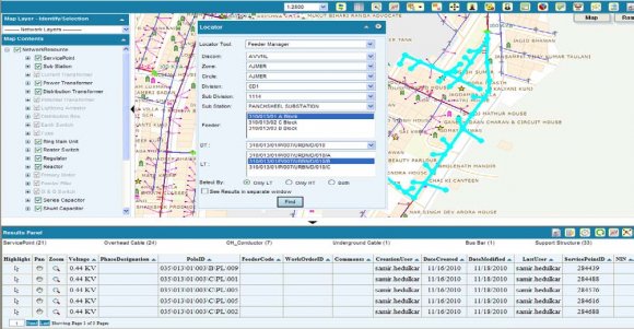
The major benefit to use GIS will be obtained only after the successful data captured for the entire HT/LT network and all the current electrical consumers. The GIS system gives error free automated inputs to the system for forecasting the future needs related to the electrical network as well as demand. This will generate automated reports to help the engineers to make the system error free and make the system up to date.
Geographic Information System consists of a system for capturing, storing, checking, integrating, manipulating, analyzing and displaying geo data related to positions on the Earth's surface and data related to attributes of the entities/Customers. It pertains to both vector and raster GIS This is achieved through GIS mapping to predefined scale, generation of intelligence electrical network maps and super imposing them on the land base GIS maps and through customization and / or development of application software.